Newly Discovered 17th-Century Secret Sea Chart Leads Bonhams' Fine Book Sale


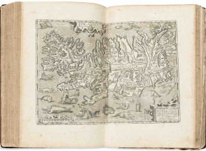
 A newly discovered 17th century seafaring chart of the Mediterranean is to be offered for sale at Bonhams Fine Books, Atlases, Manuscripts and Photographs Sale in London on Wednesday 14 June. Hidden away in a house in the West Country for decades, the sea map - known as a Portolan chart - is estimated at £40,000-60,000.
Portolan charts were first made in 13th century Italy as navigational aids. The name comes from portolano, i.e. relating to ports and harbours, and the word in modern Italian for pilot book. The development of cartography in the 15th and 16th century made the maps more accurate, and the information they carried on shipping routes and ports became extremely valuable. The Spanish and Portuguese treated their Portolan charts as state secrets and kept them under constant guard against spies acting for the English and Dutch.
The Portolan chart to be sold at Bonhams dates from 1637, and was made by Placidus Caloiro et Oliva, a member of a distinguished Catalan family of chart makers. Created in Messina, Sicily, it takes the island as its centre and shows routes to most of the islands of the Mediterranean, and the African, European and Arabian coastlines. The names of numerous costal locations appear in red and sepia in semi-italic lettering. The chart is beautifully and elaborately ornamented with compass roses, animals, town vignettes, and a roundel of the Virgin and Child.
Bonhams Head of Fine Books and Manuscripts Matthew Haley said, “Not only is this Portolan chart a beautiful object, but the European and Ottoman Empire flags scattered across it also provide a wonderfully visual impression of the spread and complexity of international rivalry in the region in early to mid -17th century.”
Image: Portolan chart of the Mediterranean, 1637. Estimated at £40,000-60,000.