AntiquarianAuctions.com Auction #50 Highlights, April 14-21


AntiquarianAuctions.com is celebrating its 50th auction after 6 years of running successful online rare book auctions, growing its database and traffic exponentially with buyers and sellers worldwide.
Even though being based in Cape Town, South Africa, the site has seen a significant increase in international buyers and collectors in the last few years.
The book trade has changed and taken to the internet as a source for quality antiquarian material.
Paul Mills, owner and founder of AntiquarianAuctions.com was recently interviewed for the article “The digital revolution - 20 years on”, published in the rare book supplement in the UK’s Antiques Trade Gazette in March 2016 which described the power of the medium and how a Cape Town based firm can receive international news coverage and trade internationally in today’s digital age.
AUCTION #50 HIGHLIGHTS
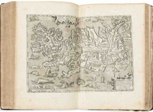
MAPS & TOPOGRAPHICAL BOOKS

A map of the extra-tropical part of Southern Africa
Published: Longman, Hurst, Tees, Orme, Brown and Green, London, 1822
William John Burchell (1781 - 1863) was a multi talented naturalist who undertook an extensive journey in southern Africa 1811 - 1815. His Travels in the interior of Southern Africa is a literary classic that included beautiful aquatints and engravings. His map was published in the first edition of the book and it is one of the landmark maps in the history of South African cartography; it is known for its relative accuracy, meticulous attention to detail and the naming of all his overnight stations and many of his hosts. While his book with the map does come on to the market, the excised map is very scarce.
Estimate: $1750 - 2500
Map of the Eastern Frontier of the Cape Colony
Published: Edward Stanford, London, 1856
Henry Hall was from Dublin, Ireland and settled in the Cape Colony in 1842. He worked in the Easter Frontier for the Royal Engineers. He is an under-appreciated cartographer who made notable contributions to cartography of Southern Africa.
Chromo-lithograph on two sheets; as issued, the map has been dissected into 24 panels mounted on linen, folded and inserted in a replacement slip case.
Estimate: $2500 - 3000
Published: Author & Cornelis Claesz, Amsterdam, 1609
This attractive map was drawn and beautifully engraved by the famous Flemish cartographer and engraver, Jodocus Hondius I (1563 - 1612). He added this map to the Gerardi Mercatoris Atlas, which he re-issued in 1606 after Mercator’s death and both he and his successor continued to publish it until 1630. The copperplate was unaltered throughout its publication, although the atlas was published ten times, six in Latin and four in French (this example of the map is from the first French edition).
The map was published in the Gerardi Mercatoris Atlas
(i.e. Atlas sive Cosmographicae Meditationes ...).
Estimate: $1000 - 1250
ALLERNEUESTER GEOGRAPHISCH - UND TOPOGRAPHISCHER SCHAU-PLATZ VON AFRICA
Published: In Verlag des Authors, Wilhelmsdorff, 1744
Size: Oblong folio (330 x 380 mm)
Splendid geographical and topographical album describing and depicting all the factories and stations of the Dutch V.O.C. in Africa and Asia. (A SOUTH AFRICAN BIBLIOGRAPHY Volume 2 page 554)
Estimate: $6000/7000
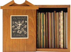
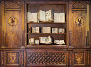
PRIVATE PRESS BOOKS
KELMSCOTT PRESS/WILLIAM MORRIS - SYR PERECYVELLE OF GALES
Published: The Kelmscott Press, Hammersmith, 1895
Size: 8vo.
Printed by William Morris at the Kelmscott Press. 98pp. Original quarter linen backed blue-grey paper covered boards. Printed in black and red from Chaucer type, title-page woodcut border after Burne-Jones, with the first line of text in red. Overseen by F.S. Ellis. One of 350 copies (of the entire edition of 358). Frontispiece by Edward Burne-Jones. Printed in Chaucer type, with titles and shoulder notes in red, and with numerous borders and initials designed by William Morris.
Estimate: $1000 - 1200
Lot 198
Lieutenant William Bligh
Published: Golden Cockerel Press, London, 1937
Two volumes. Vol.1 434pp. and Vol.2 258pp. With 4 woodcut illustrations by Lynton Lamb. Folio, 315 x 195 mm, bound in original red, blue and beige cloth, edges uncut. First Edition thus, one of 300 copies printed, this being No.160.
The log contains many important passages which do not appear in either of Bligh's published books and information patiently collected on the social life of the Tahitians. This copy comes from the esteemed library of Birch Bernstein.
Estimate: $900 - 1000
TRAVEL & EXPLORATION
NAUKEURIGE BESCHRIJVINGE DER AFRIKAENISCHE GEWESTEN
Published: Jacob Van Meurs, Amsterdam, 1676
Met lantkaerten en afbeeldingen van steden drachten &cc. na t'Leven getekendt, en in kooper gesneden. Getrokken uyt verscheyde hedendaegse lantbeschrijvers en geschriften van bereisde ondersoekers dier landen, Den tweeden druk van veel fouten verbetert.
Estimate: $6000/7000
Published: Sampson Low, Marston, Searle and Rivington, London, 1890
Size: 4to 300 x 240 mm
No 175 of the Demy Quarto Edition De Luxe limited to 250 copies signed by Henry M Stanley.
Book plate of Edna and Frank Bradlow.
'This was to be Stanley's last expedition to Africa. He was charged with rescuing Emin Pasha (Viceroy), who had been appointed a governor in the southern Sudan by the British, and had been forced to retreat to the Lake Albert (now northern Uganda) by the uprising led by an Islamic holy man. In 1888 Stanley journeyed up the Congo and to the lake, reaching Emin, who refused to leave. Eventually persuaded by Stanley, they proceeded to the Indian Ocean by way of the Semliki River which was found to connect Lake Albert with Lake Edward.' (From the facsimile reprint published by The Narrative Press, 2001.)
Estimate: $3500/4000
THE VICTORIA FALLS ZAMBESI RIVER
Published: Day and Son, London, 1865
Size: Folio (590 x 390mm)
An account of the Mosi-o-a-Tunya
(Smoke-Sounding) or Victoria Falls.
There follow eight pages of descriptive letterpress, and the plates:
1. Frontispiece, Bird's-eye View of the Victoria Falls from the West.
2. The Falls by Sunrise, with the " Spray-Cloud " rising 1200 feet.
3. The Leaping Water on the Westermost Cataract.
4. The Falls from the Western End of the Chasm.
5. Great Western (or main) Fall.
6. Herd of Buffaloes driven to the Edge of the Chasm.
7. Centre Rock Fall and the Eastern Cataracts.
8. Zanjueelah, the Boatman of the Rapids.
9. The Falls from the East End of the Chasm to Garden Island.
10. The Falls from the Narrow Neck near the Eastern Headland of the Outlet.
11. The Profile Cliff, Narrow Gorge, and Torrent of the Zambesi.
Book plate of Edna and Frank Bradlow.
Estimate: $4000/5000
ORNITHOLOGY
ATLAS De Histoire Naturelle. OISEAUX. (1865)
Published: Librairie de J. BONHOURE et Cie, Paris, no date (vers 1865)
Sought after Atlas of Natural History composed by Dr. G. H. de Schubert, with 30 carefully colored chromolithograph boards and 200 DIFFERENT KINDS of BIRDS. Names of birds on French and Latin are shown on each board. 30 double sheets (41 x 32 cm) are colored in chromolithography.
Estimate: $400-500
Next auction: Auction #51: 26 May - 2 June 2016
Contact: Paul Mills P.O. Box 186 7848 Constantia, Cape Town South Africa
E-mail: support@antiquarianauctions.com Tel: +27 21 794 0600