Rare Spanish Armada Maps on Display for the First Time
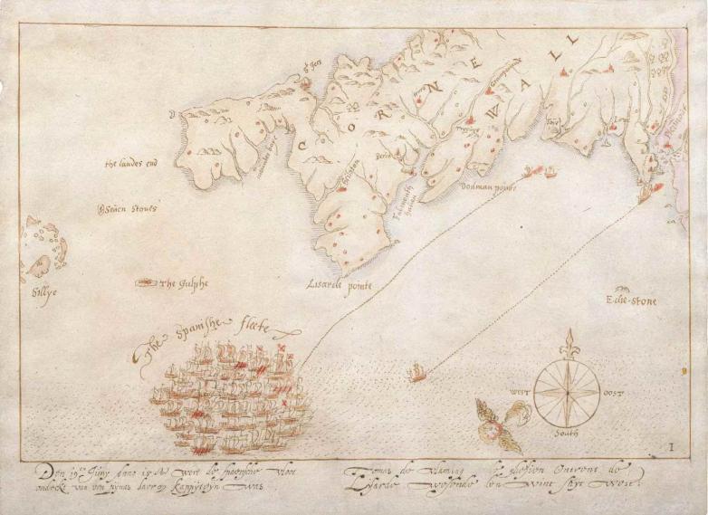
One of the Armada maps, here showing Cornwall


The Armada Maps National Treasures exhibition offers the chance to view 10 incredibly rare maps that chart the defeat of the Spanish Armada in August 1588, a defining moment in the UK’s national and naval history.
All ten maps have been put on display to the public by the National Museum of the Royal Navy for the first time in their history until August 8, 2023 at Portsmouth Historic Dockyard.
“The defeat of the Armada was a turning point in forging our nation’s identity and the maps act as a powerful commemoration of this pivotal naval battle," said Professor Dominic Tweddle, Director General of the National Museum of the Royal Navy. "The exhibition is hugely significant, an opportunity for us to link Navy to Nation and educate future generations about the origins of the Royal Navy as a protector of an Island Nation.”
The Armada Maps were first drawn in 1589 and are thought to be the earliest surviving representations of the campaign. They show in real time the defence of England’s shores against invasion in the 16th century by the Spanish fleet (141 ships and 24,000 men), dispatched with the aim of killing Queen Elizabeth I and replacing her on the throne with King Philip II of Spain. Each map details the position in the Channel of individual ships on both sides of the battle.
Conservation work on the maps revealed that red ink details were added hundreds of years after they were produced. Following expert guidance from world-leading conservation experts and The National Archives, the maps can only be displayed a limited period due to their fragile nature and the dangers of exposure to light. This exhibition also explores the build up to the Armada campaign and includes an extremely rare map from May 1588 of the Spanish Armada outside Lisbon.
The ongoing story of the Armada and its resonance throughout history is also unpacked, through later representations of the maps, especially those by engraver John Pine. Visitors can digitally engage with the maps through an on-gallery touchscreen and animation created specifically for the exhibition.
The maps were saved from being sold overseas in 2021 after the National Museum of the Royal Navy raised £600,000 following an export bar in order to prevent their sale abroad.