Map Believed Stolen from the Boston Public Library Is Found and Returned


BOSTON—Today, the Boston Public Library (BPL) announced that a map believed stolen from the library more than a decade ago, has been located at a New York City antiques dealer, and has been returned. The map, Carte Geographique de Nouvelle France, compiled in 1612 by explorer Samuel de Champlain, was found for sale with an antiques dealer for $285,000. The map, which has prominent identifying marks, was discovered by Norman B. Leventhal Map Center curator, Ronald Grim, and a third party expert has confirmed its ownership. The map will be on display in the Norman B. Leventhal Map Center at the Central Library in Copley Square from December 4, 2015 through February 29, 2016.
“I want to recognize Ronald Grim for his attention to detail and passion for his work at the Norman B. Leventhal Map Center at the Boston Public Library,” said Mayor Walsh. “The library has one of the nation’s premier map collections, and I’m pleased we have restored this centuries old historic map to the collection.”
“This is a very significant collection managed by the Norman B. Leventhal Map Center. The combined holdings include nautical charts, ornate maps, atlases, and some of the earliest printed maps in the world,” said David Leonard, Interim President of the BPL. “I want to thank Ronald Grim for his incredible expertise and thoroughness in identifying this map and taking action to report it. The cultural and educational value of this collection will be all the stronger with its return. This return is a triumph of BPL’s curatorial diligence and early digitization expertise at their best.”
“I was stunned to come across the map, and thrilled to determine it indeed belongs to the Boston Public Library,” said Grim. “I’m proud it’s been returned to its rightful home.”
Shortly after Grim arrived at the Boston Public Library in 2005, he discovered that the map was missing from a book describing Champlain’s exploration in North America, Les Voyages du Sieur de Champlain, published in Paris in 1613. He made this discovery while inventorying maps following the arrest of E. Forbes Smiley for the theft of maps at Yale University in June 2005. As a result of Grim’s inventory, it was determined that 69 maps out of BPL atlases and books were missing. Thirty-three of the missing items have since been recovered (not including the Champlain map), and Forbes Smiley confessed to stealing 34. Smiley served three years in jail for stealing historic maps from other institutions, including Yale University, New York Public Library, Harvard University, Newberry Library, and the British Library.
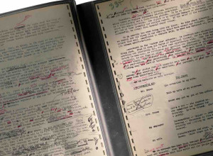
Grim identified the missing Champlain map in an antiques publication earlier this summer, and compared the markings on the map being held at the dealer with a digital scan of a 4x5 inch negative of the map dating to 1992. The missing map has prominent tears on its left side, and a small hole at the juncture of two fold lines just above the middle tear. Despite conservation efforts since the item was in the BPL’s possession, Grim was able to determine that the markings on the map are consistent with the BPL’s digital record. A third party conservation expert, Scott Gerson, was retained, examined the map, and confirmed Grim’s findings. The antiques dealer, who has been fully cooperative with the BPL during this process, had been retained by a third party to sell the map on commission.
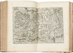
Samuel de Champlain made 20 voyages across the Atlantic between 1603 and 1613, exploring much of eastern Canada and the coast of New England. Champlain compiled several maps related to his explorations, but the Carte Geographique de Nouvelle France was the first published map recording his early explorations. The map, which measures 17 inches by 30 inches, shows the coast of New England and the Canadian Maritime Provinces, and the St. Lawrence River Valley as far west as the Great Lakes. The map is adorned with depictions of Canadian flora and native peoples. The Leventhal Map Center assumed responsibility for the BPL’s atlas and map collection in 2007.