Archive Illuminating Perry's Trade Negotiations with Japan Comes to Auction


 New York - Swann Galleries’ auction of Maps & Atlases, Natural History & Color Plate Books on Thursday, December 13 offers an impressive group of Japanese maps, East Coast cartography, American atlases and important non-cartographical works.
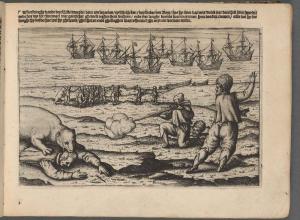
A robust selection of Japanese cartography, representing both the East and the rest of the world, sets this maps auction apart. A color woodblock map of Uraga and Edo Bay relating to Commodore Matthew Perry and his Black Ships leads the assortment and is offered with a complete bound volume of 18 miniature kawaraban (early Japanese newspapers with woodblock illustrations). The archive shows the course of Commodore Perry’s Black Ship squadron and illustrates the opening of Japan’s trade with America in 1854. It is expected to bring $7,000 to $10,000.
Additional Japanese cartography includes an extensive panoramic diagram of the roadways, waterways, cities and topography of the entire island chain of Japan, and a large woodblock plan of Kyoto (Estimate: $2,500-3,500 and $1,200-1,800, respectively). A run of sugoroku-Japanese game boards-feature in the sale: an unusual and rare world map manga gameboard takes its player around a variety of international sites and was published for young women in 1934, and Eisen Tomioka’s Shina Seibatsu Sogoroku, a Sino-Japanese War propaganda game, each at $700 to $1,000.
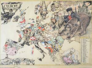
Cornelis De Jode’s rare world map, Hemispheriu ab Aequinoctiali Linea, leads the sale. The second of two that appeared in De Jode’s Speculum Orbis Terrarum, 1593, the map features a two-paged double-hemispheric view of the world and carries an estimate of $20,000 to $30,000. Other world maps include John Speed’s A New and Accurate Map of the World, 1676. The double-page, double-hemispheric decorative world map is hand colored in full and expected to sell for $6,000 to $9,000.
A selection of maps relating to the North America’s East Coast include a 1780 chart of the middle Atlantic Coast including New York, New Jersey, Pennsylvania, Maryland, Virginia and North Carolina by Joseph Frederick Wallet Des Barres. The sea chart is monumental at nearly six feet tall and is valued at $18,000 to $22,000. A panoramic excursion view of Rhode Island’s Narragansett Bay and Block Island, housed in a charming device that allows you to slowly scroll through the area as if you are on a paddle steamer, is estimated at $6,000 to $9,000; William Faden’s The Province of New Jersey, 1778, features The Jerseys divided into East and West, at $6,000 to $9,000; and Otto Sibeth’s large map of Central Park in New York City, showing the park in detail and noting species of plants, is expected to bring $1,500 to $2,500. A New American Atlas Containing Maps of the Several States of the North American Union, 1825, by Henry Schenck Tanner is valued at $12,000 to $18,000. Tanner’s atlas received contemporary praise for its clarity, attractiveness and attention to American detail. Additional atlases include the 1827 North American volume of Philippe Vandermaelen’s monumental world atlas, Atlas Universel de Georaphie Physique. The work is distinct for being the first to utilize lithography as the method of production and features newly emerging areas of the American West in a larger scale than had previously been seen ($6,000-9,000).
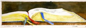
A highlight of color plate books is John James Audubon’s The Birds of America, 1859, with seven volumes and 500 tinted and hand-colored lithograph plates. The work is offered together with Audubon’s The Quadrupeds of North America, all in matching octavo bindings at $20,000 to $30,000. Art Nouveau artist Anton Seder is available with Das Trier in der Decorativen Kunst, 1896-1903, a rare portfolio featuring dragons, lizards, lobsters, birds and other exotic, fanciful and beguiling beasties ($2,000-3,000).
Of the historical prints and drawings available in the sale of note is Across the Continent, 1868, from Currier & Ives which demonstrated the changing landscape of the mid-nineteenth century American frontier upon the completion of the Transcontinental Railroads. The present example comes by descent from the collection of renowned Americana collector Thomas Winthrop Streeter ($7,000-10,000). English artist and illustrator Edward Lear makes an appearance with an assortment of watercolor illustrations of Castello di Melfi in Basilicata and Castello di Lagopesole, each valued at $3,000 to $5,000.
Ephemera features an enormous album of wide-ranging postcards from Frank Crowe, a musician who in his youth stole away to join the circus. The nearly 2,500 postcards come from the late-nineteenth and early-twentieth centuries and showcase Crowe’s adventures touring Europe and America with Barnum and Bailey, King and Franklin, and other circuses ($700-1,000).
The complete catalogue and bidding information is available at www.swanngalleries.com.
Additional highlights can be found here.
Image: Lot 110: Color woodblock map of Uraga and Edo Bay showing the course of Commodore Perry’s Black Ship squadron, Japan, circa 1854. Estimate $7,000 to $10,000.