Antique Maps of Africa, Online Auction Running Jan. 21-28


AntiquarianAuctions.com is an online auction site dedicated to the sale of rare and out-of print books, maps & prints, documents, letters, ephemera and vintage photography.
All pricing is done in US$. No buyer’s premium is charged.
Please find below a selection of the maps, for all stock visit:
www.antiquarianauctions.com/category/antique-maps-atlases
Lot 287
Sayer & Bennett
Plan of Table Bay with the Road of the Cape of Good Hope, from the Dutch Survey Published by Joannes van Keulen
Published: Sayer & Bennett, London, 1778
Edition: 1st
Overall Condition: Very Good; some fine creases
Size: 54.1 x 48.0cm
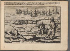
This is the first publication, in 1778, of the very scarce English sea chart and plan of Cape Town and environs, drawn from Van Keulen’s 1728 information. (Van Keulen published the map in 1753 in de Marre, J.; van Keulen, J. (1753). De Nieuwe Groote Lichtende Zee-Fakkel.)
Although this edition of the maritime map is a scarce cartographic anachronism, it provides very important historical detail, from the 1720s of the developing Cape Town, a time when the Dutch colony has expanded beyond the Liesbeeck River and when the VOC kept secret their sea charts and maps of the colony.
This is a scarce sea chart of Table Bay and a plan of the surrounding land is an under-appreciated landmark map of the Cape of Good Hope: it provides an important cartographic record of the region in the 1720s.
Estimate: $2250
Lot 285
John Thornton
A Draught of Cape Bona Esperanca
Published: Samuel Thornton, London, 1734
Overall Condition: Fine
Size: 53 x 43 cm
This sea chart is a very scarce milestone in the history of mapping of the Cape of Good Hope and its coastline.
The chart was engraved on copperplate by John Thornton (1641 - 1708).
It was published in English Pilot (Part V) 1734, 1743 and 1761.
Thornton was an engraver, hydrographer and publisher who succeeded John Seller (c.1630-1697). Seller was the first Englishman to compete with the Dutch in the production and publication of sea-charts; this inaccurate chart was produced, when the VOC kept its maps secret, from a Dutch source, Kaart van Saldanhabaai tot de Falsbaai by Caspar van Weede .
(4.VEL 168 in the Dutch National Archives).
Estimate: $2750
Lot 280
Giovanni Battista Nicolosi:
Africa Ioanne Baptista Nicolosio S.T.D. Sic Describente
Published: V Mascardi, Rome, 1660
Overall Condition: Fine
Size: 92cmx79cm, when joined. Edition: 1st
Giobattista Nicolosi (1610 - 1670), a priest from Sicily, was a cartographer for the Pope Gregory XV’s Sacred Congregation for the Propagation of the Faith, established by the pope to promote missionary work.
This map, printed from an engraved copperplate, is one of a set of four continents and a world map that he produced for the second volume of Dell' Hercole e studio geografico di Gio. Battista Nicolosi.
The map is based on Sanson’s 1650 map, but follows Ramusio and earlier Italian cartographers in that south is on top.
The first state of the map is scarcer than the second. This is an unusual and much sought after, uncommon after “upside down” map in its first state.
All four panels of the map are in fine condition; they are usually joined and tarnished by glue stains.
Estimate: $3000
Lot 281
Anathasius Kircher
Hydrophylacium AFRIC? precipuum, in Montibum Lunæ Situm, Lacus et Flumina præcipu| fundens. ubi et nova invention. Originalis Nili de?cribitur.
Published: Johannes Janssoniuis & Elizeus Weyerstraten, Amsterdam, 1665
Edition: 1st
Overall Condition: Fine
Size: 41.5 X 34.5 cm
Anathasius Kircher (1601 - 1680) was a respected German Jesuit scholar and inventor who studied many subjects, notably geology, medicine and the Orient. He is considered the founder of Egyptology. He was one of the first people to observe microbes under a microscope and suggested that the plague was caused by micro-organism. He was a “scientific star” of his time and has been compared to da Vinci in terms of depth and breadth of knowledge and inventiveness. In 1633, he answered a call to Rome by Pope Urban VIII and was appointed professor of mathematics, physics, and oriental languages at the Collegio Romano. He resigned in 1641 to pursue independent studies.
The mythology of this map has its origin in a journal left by a contemporary Jesuit colleague of Kircher, Peter Páez, whose journal contains a fantasy: the Nile flows from a subterranean lake under the Mountains of the Moon.
Estimate: $450
Lot 107
R V Tooley
COLLECTOR'S GUIDE TO MAPS OF THE AFRICAN CONTINENT AND SOUTHERN AFRICA
Published: Carta Press, London, 1969
Edition: 1st
132 Pages plus 100 black and white plates with reproductions of maps and 6 colour plates. Descriptions of 500 maps of Africa.
Estimate: $55-60
AntiquarianAuctions.com is an online auction site dedicated to the sale of rare and out-of print books, maps & prints, documents, letters, ephemera and vintage photography.
Dealers and collectors worldwide have been selling and bidding on the site since 2010.
Only established booksellers who are members of major national trade associations such as ABA, ABAA, PBFA or SABDA or are of good standing in the trade are permitted to sell on the site.
Auctions are held every five weeks and run on the model of a timed auction for one week.
Next auction: Auction #49: 3 -10 March 2016
Contact:
AntiquarianAuctions.com: Paul Mills
E-mail: support@antiquarianauctions.com
UK: +44 (0)20-3695-3172
US toll free: +1 855-245-1612
SA +27 (0)21-794-0600