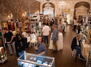
Sale of Canal and River Books at Chiswick Auctions


Chiswick Auctions is proud to announce its upcoming sale of Canal and River Books which will be taking place on Wednesday 4th November. View the catalogue.
From the private collection of Mark Baldwin, one of the UK’s most prolific canal book collectors, the auction is set to be an industry game changer.
Having bought his first waterway book in the 1950s ‘The Wanderings of the Beetle’ (1885) as a teenager, he has been avidly collecting ever since. Resulting in one of the biggest inland waterways libraries in the country and it is this collection that will available at Chiswick Auctions on 4th November.
It was the acquisition of Charles Hadfield’s waterway collection in the 1970s which instigated Mark’s ascent into the world of more serious collecting, as it vastly extended his own collection and gave him the impetus to build one of his own. This was facilitated by becoming a book-seller in 1978, part-time at first before progressing to full-time in 1986. In between this time, Mark became an author, publishing the first comprehensive bibliography on British canals, in addition, he has also gone onto lecture on the subject.
Available in the auction will be a strong canal book collection featuring incredible material from not just the United Kingdom but around the world. With over 1000 items across over 200 lots, the sale is set to be an exciting one.
Star lots include:
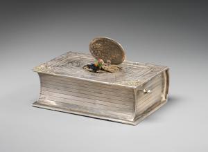
Lot 136 - BRADSHAW, George. G. Bradshaw’s Map of Canals, situated in the counties of Lancaster, York, Derby & Chester . . . 2nd edn, ND [1833]. 910 x 1290, dissected into 32 panels, mounted on linen, edges bound with green tape (some becoming loose). Map good. Skempton 112, together with G. Bradshaw’s Map of Canals, Navigable Rivers, Rail Roads &c in the Midland Counties of England. 1st edn, 3rd state, 1830. 1270 x 1260, dissected into 48 panels, mounted on linen, edges bound with green tape (some becoming loose). Map good. Skempton 116. These two maps, together with an MS note by Professor Skempton, are enclosed in a purpose-made rigid leather-covered box (some wear), made to look like a leather-bound book. The top half lifts off to allow removal of the contents. Estimate: £300-£500
Lot 137 - BRADSHAW, George. G. Bradshaw’s Map of Canals, Navigable Rivers, Railways &c in the Southern Counties of England. 1st edn, 1st state, ND [c1832]. In 3 sheets (as issued), each 650 x 720, dissected into 12 panels, mounted on linen, edges bound with green tape. Skempton 119, together with a bound booklet (230 x 140) containing. Lengths and Levels to Bradshaw’s Maps . . . London: Ruff (printer), 1833. 15pp, and Canals and Navigable Rivers. pp5-20 + fldg map Continuation of the Lea Navigation and River Stort and Continuation of the Grand Junction Canal and the Proposed London & Birmingham Rail Way and Lengths and Levels to Bradshaw’s Maps . . . London: White (printer), 1832. Skempton 124, together with a bound booklet (230 x 140) containing Lengths and Levels to Bradshaw’s Maps . . . London: Ruff (printer), 1833. 15pp, and Canals and Navigable Rivers. pp5-20 + fldg map Continuation of the Lea Navigation and River Stort and Continuation of the Grand Junction Canal and the Proposed London & Birmingham Rail Way and Lengths and Levels to Bradshaw’s Maps . . . London: White (printer), 1832, and CUBITT, W. Description of a Plan for a Central Union Canal which will Lessen the Distance and Expense of Canal Navigation between London and Birmingham, and unite the Birmingham - Warwick and Birmingham - Coventry - and Oxford Canals . . . . London: Roake & Varty, 1832. Large fldg map (edges frayed), 7pp. Some browning, front hinge broken. Skempton 124 and 315. These three map sheets, and two booklets, together with an MS note by Professor Skempton, are enclosed in a purpose-made rigid leather-covered box (some wear), made to look like a leather-bound book. The top half lifts off to allow removal of the contents. Estimate: £350-£500
Lot 148 - WALKER, John. Map of the Inland Navigation, Canals and Railroads . . . throughout Great Britain . . .Wakefield: Nichols, 1803. Very large hand-col fldg map (192 x 157), dissected into 54 panels, mounted on linen, covering whole of England, Wales and Scotland. Green edging tape worn and frayed, map good. The map is enclosed in a purpose-made rigid leather-covered box (some wear), made to look like a leather-bound book. The top half lifts off to allow removal of the contents. This is the map to which the Lots 100-102 refer. Estimate: £350-£500
Lot 157 - BRADSHAW, George. G. Bradshaw’s Map of Canals, situated in the counties of Lancaster, York, Derby & Chester . . . 2nd edn, ND [1833]. 910 x 1290, dissected into 32 panels, mounted on linen, edges bound with green tape. Very good condition. Skempton 112. Together with G. Bradshaw’s Map of Canals, Navigable Rivers, Rail Roads &c in the Midland Counties of England. 1st edn, 3rd state, 1830. 1270 x 1260, dissected into 48 panels, mounted on linen, edges bound with green tape. Very Good condition. Skempton 116. These two maps are enclosed in a purpose-made rigid leather-covered box (some wear), made to look like a leather-bound book. The top half lifts off to allow removal of the contents. Estimate: £400-£600
Lot 158 - BRADSHAW, George. G. Bradshaw’s Map of Canals, Navigable Rivers, Railways &c in the Southern Counties of England. 1st edn, 2nd state, ND [c1833]. In 3 sheets (as issued), each 650 x 720, dissected into 12 panels, mounted on linen, edges bound with green tape. Very Good condition. Skempton 120, together with a bound booklet (230 x 140) containing, Lengths and Levels to Bradshaw’s Maps . . . London: Ruff (printer), 1833. 15pp. and Canals and Navigable Rivers. pp5-20 + fldg map Continuation of the Lea Navigation and River Stort and Continuation of the Grand Junction Canal and the Proposed London & Birmingham Rail Way and Lengths and Levels to Bradshaw’s Maps . . . London: White (printer), 1832, and CUBITT, W. Description of a Plan for a Central Union Canal which will Lessen the Distance and Expense of Canal Navigation between London and Birmingham, and unite the Birmingham - Warwick and Birmingham - Coventry - and Oxford Canals . . . . London: Roake & Varty, 1832. Large fldg map (edges frayed), 7pp. Some browning, hinges strained. Skempton 124 and 315. These three map sheets, and the booklet are enclosed in a purpose-made rigid leather-covered box (some wear), made to look like a leather-bound book. The top half lifts off to allow removal of the contents. (2) Estimate: £350-£500
Lot 145 - VERNON-HARCOURT, Leveson Francis. Rivers and Canals . . . Oxford: Clarendon, 1896. 2nd edn. 2 vols. 230 x 150. xx + 342pp, 10 fldg col pl; xii + pp343-704, 3 fldg col pl.. Orig brown cloth, bright gilt, front hinge of Vol 1 splitting. Completely written and re-structured, with Vol 1 now ‘Rivers’ and Vol 2 ‘Canals’. 2 Vols. Estimate: £75-£125
Lot 156 - Very early inland navigation book - Badeslade, 1725
BADESLADE, Thomas. The History of the Ancient and Present State of the Navigation of the Port of King’s-Lyn, and of Cambridge . . . London: Roberts (printer), 1725, FIRST EDN. 405 x 260. [xii] + 148pp + 7 hand-col plans. (4 fldg). Near contemp full calf, pitted, with fine new calf spine, red titling piece, raised bands. Pages slightly browned and wrinkled, but overall in very good condition for its age. Estimate: £400-£600
Lot 162 - Full set of Royal Commission reports
Royal Commission . . . on Canals and Inland Navigations of the United Kingdom. HMSO, 12 vols bound in 11, 1906-1911. Uniformly bound in half calf and cloth-covered boards by James Truscott & Son, ‘Contractors for Bookbinding to H. M. Government’. Stamps of British Railways Board Archives. Over five thousand pages, fldg maps. Some rubbing to extremities and spines, rear board of Vol 1 dented and marked, surface damage to spine of Vol IX, but all volumes are soundly bound and internally clean. A very rare opportunity to acquire a complete set of the reports of the most comprehensive survey ever undertaken of the waterways of the British Isles. The Commission’s recommendations for improvements were never implemented, partly because of the vociferous railway lobby, exemplified by Edwin PRATT (see Lot 146), partly by the increasing tension leading up to the Great War. See Lot 166 for a separate copy of the main map. Estimate: £1,500-£3,000
Lot 182 - 200 year old document from Cromford Canal
CROMFORD CANAL Co. The company’s record of 576 permits issued to individual canal boats from 9 October to 5 November 1829. On printed forms are entered, in MS, the boatman’s name, the boat’s owner, the cargo, places of loading and landing, gauging record, weight of cargo, miles travelled, charge per ton, amount due. Each permit would originally have had a second counterpart, which would be cut off and given to the boatman. These retained sections of the permits were bound together in a hard binding of quarter calf, and flush-cut marbled boards. The binding, now dusty and worn, has broken but the contents are complete, comprising permits numbered from 4651 to 5226. Estimate: £150-£300
The first four books about cruises on Britain’s waterways (Lot 208-211)
Lot 208 - The first ever book describing a small-boat cruise on British waterways. DASHWOOD, J.B. The Thames to the Solent by Canal and Sea, or the Log of the Una Boat ‘Caprice’. London: Longmans, Green, & Co. 1st edn 1868. 185 x 120. xi, frontis, fldg map in 2 cols, 91, 6 drgs. Orig green cloth, rubbed at corners. Corner cut from front free endppr. Gen VG. Charles Hadfield’s copy. Route included Wey Navigation, Wey & Arun Canal, Arun Navigation. Estimate: £200-£400
Lot 209 - The second book describing a small-boat cruise on British waterways. ANON [SCHOFIELD, A.] The Waterway to London, as explored in the “Wanderer” and “Ranger”, with Sail, Paddle, and Oar, in a voyage on the Mersey, Perry, Severn, and Thames, and several canals. London: Simpkin, Marshall, & Co. 1st edn 1869. 185 x 125. Frontis, 96, 12 pl (of which 2 are maps). Paper browning. Orig green cloth somewhat rubbed. Aeg. On the title page, after the words ‘Special Artist’ are written the ink initials ‘R.H.A.S.’ Another copy has, reportedly, a presentation inscription ‘R.Harold A. Schofield’ dated Aug 21/69. A third copy has, reportedly, on page iii, under the printed words ‘THE AUTHOR’ a manuscript inscription ‘Alfred Taylor Schofield’. It therefore seems likely that the author was Alfred Taylor Schofield, and that a relative of his, R. Harold A. Schofield, was a member of the crew, and drew the pictures. Their route included the Bridgewater Canal, Ellesmere Canal, River Severn, Gloucester Ship Canal, Thames & Severn Canal, etc. Estimate: £300-£500
Lot 210 - The third book describing a small-boat cruise on British waterways. HEAVISIDE, George. Canoe Cruise down the Leam, Avon, Severn and Wye. London: Whitfield, 1st edn 1871. 160 x 105. 102pp. Orig blue cloth, VG. Estimate: £150-£300
Lot 211 - The fourth book describing a small-boat cruise on British waterways. RED ROVER. Canal and River: a canoe cruise from Leicestershire to Greenhithe, including a guide to the Thames below Oxford. Bedford: Rowland Hill, 1st edn 1873. 180 x 125. 90pp. Handsome contemporary binding of red half-calf, red cloth, raised bands. Presentation copy, inscribed ‘Henry Thorpe/with the kindest regards of/Red Rover/Oct 10th 1973.’ Charles Hadfield’s copy. The route included the Grand Union, Grand Junction, and Oxford Canals. Estimate: £200-£400
Lot 218 - Landscape With Machines. 1st edn 1971. Complete Dw. F; Landscape With Canals. 1st edn 1977. Complete Dw. F; Landscape With Figures. 1st edn 1992. Complete Dw. F. High Horse Riderless. 1st edn 1947. Complete Dw. F; The Clouded Mirror. 1st edn 1955. Complete Dw. F. Three volumes of autobiography, and two of philosophy. (5) Estimate: £100-£250
Lot 232 - The Clouded Mirror. 1st edn 1955. VG in price clipped Dw. Correction slip tipped in on p 122. Red For Danger. 1st edn 1955. VG in complete, sl dull, Dw. Estimate: £50-£100
Lot 234 - Motoring History. 1st edn paperback. VG; Look at Canals. 1st edn 1962. Complete Dw. F; The Story of Brunel. 1st edn 1965. Price-clipped Dw. F; Inside a Motor Car. 1st edn 1964. Glazed pictorial boards. VG; How Things Developed: Inland Waterways. 1st edn. Pictorial boards, spine faded, o/w VG; Red For Danger. 1st edn 1955. Spine dull o/w VG; The Inland Waterways of England. 2nd imp 1955. Spine rubbed, spine head frayed, front hinge strained. Landscape with Canals. 1988 paperback reprint. VG; Thomas Telford. 4th imp 1965. VG in complete Dw; Worcestershire. 1st edn 1949, better issue. Complete Dw. VG. (10) Estimate: £50-£100
Lot 376 - Hugely rare official 1944 publication helping to plan for the invasion of Germany
An unusual opportunity to acquire very important documents, prepared for the Allied invasion of Europe in World War 2. THE WAR OFFICE (M.I. 10c). The Rhine System. Part 1. The Rhine. June 1943. Title page headed ‘SECRET’. A large volume, 360 x 220, bound in stout dark green buckram, lettered in gilt. 140pp, (irregularly numbered). About 26 pp of text, plus 13 fldg 2-col maps, 3 dble-page profiles, 19 2-col port plans, approx 146 real photos, hand-mounted (up to 3 per page) showing bridges, locks, wharves, basins, industrial plants, vessels, etc. This is copy No 28, bearing the stamps of the Railway Research Service, 21 Sep 1943. It is initialled ‘A de T’ [i.e. A. de Tscharner] for the War Office on p 3. Loosely inserted is an Amendment sheet, dated 10 Aug 1944, with extra or corrected information, bearing the stamp of the Railway Research Service, 17 Aug 1944. Together with THE WAR OFFICE (M.I. 10c). The Rhine System. Part2. Navigable Tributaries. Jan 1944. Title page headed ‘SECRET’. A large volume, 355 x 215, bound in stout dark green buckram, lettered in gilt. 152pp (irregularly numbered). Contains information (comparable to that in Vol 1) on the rivers Neckar, Main, Lahn, Mosel, Saar, Ruhr, Emscher, and a number of connecting canals. Approx 157 photos, hand-mounted (up to 3 per page) showing bridges, locks, wharves, basins, industrial plants, vessels, etc. many plans, profiles, etc (some fldg). This is copy No 28, bearing the stamp of the Railway Research Service, 22 Apr 1944. It is signed A de Tscharner for the War Office on p 1. A wealth of information is contained in these books, a tribute to the thoroughness of M.I 10, and the efforts they put into preparations for the final drive across Europe. The actual volumes themselves are the product of a great deal of craftsmanship - title pages and photo captions are hand-written in Indian ink, each photo has a hand-drawn Indian ink frame, photos (and other elements) are hand-mounted, etc. Both volumes are in excellent fresh condition, with almost no wear. (2)
Estimate: £400 - £1,000
There are lots of ways you can bid. Visiting our saleroom at 1 Colville Road, Chiswick W3 8BL, in person is always an exciting experience but if you cannot make it, then you can bid online from your computer via saleroom.com. For added convenience, you can also request a telephone bid, or indeed leave a commission bid prior to the sale.
Viewing:
The items will be available to view on Sunday 1st from 12 - 6pm, Monday 2nd from 10am - 6pm, Tuesday 3rd from 10am - 6pm and on Wednesday 4th before the sale starts from 10am - 1pm. This is a chance to come and take a closer look at the collection in full.