Sea Monsters and Old Maps


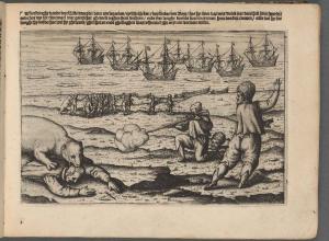
 There are few things quite so charming as the images of sea monsters that turn up on old maps -- personal favorite: the map of Iceland surrounded by sea monsters done by Abraham Ortelius in 1585. What's charming to me, however, was terrifying to sailors for centuries.
 Now those sea monsters are getting some deserved scholarly attention, thanks to Chet Van Duzer, an invited research scholar at the John Carter Brown Library and soon-to-be research curator in the geography & maps division at the Library of Congress. His new book, Sea Monsters on Medieval and Renaissance Maps (British Library/U. of Chicago Press, $35), is illustrated with 147 color images. Van Duzer analyzes the most important examples of this decorative cartography from the tenth century to the end of the sixteenth, examining each mapmaker's sources and influences.
Van Duzer is also the co-author of last year's Seeing the World Anew: The Radical Vision of Martin Waldseemüller's 1507 & 1516 World Maps.