Rare Cartography and Exploration Coming up at PBA Galleries


On October 29th, 2015, PBA Galleries in San Francisco will hold the first of three auctions of Rare Cartography, Exploration and Voyages: The Warren Heckrotte Collection, followed by sales on December 3, 2015, and March 10th, 2016. Built over a span of more than fifty years, the superb collection features rare and important landmarks in the exploration of the Americas, particularly the Pacific slope and the northwest coast. On offer will be items rarely or never seen at auction, tracing the expansion of cartographic and geographic knowledge from the 16th through 20th centuries, including maps, atlases, books, even rare geographic jigsaw puzzles and games.
Warren Heckrotte began collecting rare books and maps in the early 1960’s, when called to Geneva, Switzerland, to add scientific expertise, as a nuclear physicist at the Lawrence Berkeley Laboratory, to the ongoing nuclear test ban treaty talks between the United States and the Soviet Union. In his off hours he would rummage through the book stores and stalls of the city, fascinated by the history to be discovered, and purchasing rarities for what would be considered a pittance today. He spent much of the next decade and a half traveling back and forth between the U.S. and Switzerland, and even spent some time in the Soviet Union, stopping at the London booksellers and auction houses on the way, with Maggs, Quaritch, Sotheby’s and Christie’s all providing additions to his growing collection. Back in the San Francisco Bay Area he was a favored customer at John Howell Books, Alta California Books, Argonaut and others. Not content just to acquire material, Mr. Heckrotte studied it in scholarly fashion, and drew his own conclusions. He contributed articles to such publications as Terra Cognita (newsletter of the Society for the History of Discoveries), The Map Collector, Mercator’s World, and the newsletter of the California Map Society. He edited, and largely wrote, California 49: Forty-nine Maps of California from the 16th Century to the Present, published in San Francisco in 1999. Mr. Heckrotte also curated a number of exhibits of his material at the Book Club of California. PBA Galleries is pleased to make use of Mr. Heckrotte’s scholarly descriptions of his collection in the preparation of the catalogues.
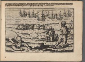
Part I in the series of auctions consists of “Exploration and Early Approaches,” from the beginning of the mapping of the New World through the epic discoveries of Lewis and Clark. The highlights include, but are not limited to, John Green’s A Chart of North and South America, on six sheets, 1753, published by Thomas Jefferys, bound with the “Remarks,” in period red morocco, estimated at $20,000-$30,000; John Briggs, The North Part of America, 1625, the first printed map in English, and the second overall, to show California as an island, expected to sell for between $10,000 and $15,000; George Vancouver’s A Voyage of Discovery to the North Pacific Ocean, and Round the World, 3 volumes plus the atlas, London: 1798, with an estimate of $25,000-$35,000; Miguel Costansó, Carta Reducida Del Oceano Asiatico, ? Mar Del Sur, Que Comprehende La Costa Oriental Y Occidental De La Peninsula De La California, an engraved map, published in Madrid in 1771 or a bit later, being the first printed map to show San Francisco, with only a few copies known to exist - it has a predicted sale price of $15,000 to $25,000; and Gerhard Friedrich Müller’s Nouvelle Carte des Decouvertes Faites Par Des Vaisseaux Russes Aux Côtes Inconnues De L'Amerique Septentrionale, published in St. Petersburg, Russia, in 1754, the very rare first issue of the map, displaying the discoveries made by the second Bering expedition, at $15,000-$25,000.

Part II of the Heckrotte collection, on offer December 3, 2015, bears the subtitle “California and the Way Tither,” concentrating on California and adjacent states and territories, with much on the Gold Rush and the overland journeys and expeditions it engendered. Among the main features is a superb collection of maps of the California Gold Region, most of them folding pocket maps. Among the highlights: Thomas O. Larkin’s Map of the Valley of the Sacramento including the Gold Region, Boston, 1848, regarded as the first published map to show or designate the gold region, folding into original cloth covers, estimated at $15,000-$25,000; William M. Eddy, Official Map of the State of California, the rare, seminal, and quite large folding map (now flattened) of the state, this copy signed by Eddy (who died before most copies were available to the public) on the inside of the folder - it also is expected to sell for between $15,000 and $25,000; Hosea B. Horn, Horn’s Overland Guide…to the City of Sacramento, in California, published in New York in 1852, with a folding map, an exceptional copy, with an estimate of $8,000-$12,000; William A. Jackson’s Map of the Mining District of California, New York: 1850, a very rare lithographed map, folding into leather covers, one of only about five copies known, predicted to bring between $10,000 and $15,000; and George H. Goddard, Britton & Rey's Map of the State of California, published in San Francisco in 1857, a hand-colored folding lithographed map, considered to be the first reasonably accurate map of California, this being the very rare first issue, with an estimate of $10,000-$15,000.
Part III of the auction of the Heckrotte collection, March 10, 2016, is “Filling in the Gaps,” mapping other states and regions, and further refining the state of geographic and cartographic knowledge. Among the many rarities is John Melish’s Map of the United States with the contiguous British and Spanish Possessions, the 1818 issue, a large engraved map hand-colored in outline, backed with linen and sectioned for folding, in the original marbled boards folder, bearing an estimate of $30,000-$50,000; Jacob de Cordova’s Map of the State of Texas, a hand-colored lithographed map, folding into the original leather covers, this being the 1849 first printing, the first official map of Texas as a state, on a far larger scale than any previous, projected to sell for between $60,000 and $90,000; Carlos Roca and Domingo Estruch, Carta Geogro. Topográfica De La Isla De Cuba, published in Barcelona, Spain, in 1835, a very large engraved map on six sheets, the first topographical map of Cuba, considered a masterpiece of Spanish printed cartography, estimated at $15,000-$25,000; Aaron Arrowsmith, A Map Exhibiting all the New Discoveries in the Interior Parts of North America, on three sheets, hand-colored in outline, London, 1796, the second issue of this important map, and the first 1796 issue, with a predicted price of $10,000-$15,000; and finally, F. & R. Lockwood’s The Traveller’s Tour Through the United States, published in New York in 1822, a geography game with 139 stops, which participants have to name when they land upon them, and even give the population - it is considered the first American board game, and is exceedingly rare, estimated to sell at $20,000-$30,000.
There will be an additional auction containing material from the Heckrotte collection, including reference books, secondary sources, supporting text, and duplicate items, on a date yet to be determined. Complete sets of catalogues of the Heckrotte auctions may be ordered in advance - Please contact PBA Galleries for more information.
For more information regarding upcoming sales, consignments, or auction results, please contact PBA Galleries at (415) 989-2665 or pba@pbagalleries.com or visit www.pbagalleries.com.
First image: Miguel Costansó, Carta Reducida Del Oceano Asiatico, ? Mar Del Sur, Que Comprehende La Costa Oriental Y Occidental De La Peninsula De La California.
Second image: John Briggs, The North Part of America.