Waterloo and More at the 36th London Map Fair


The world’s largest antique map fair will once again be held in the historic environs of the Royal Geographical Society on June 6 and 7.
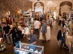
Over 40 leading map dealers will gather from across the globe bringing an unparalleled array of original antique maps, charts, town plans, atlases and globes. Thousands of maps covering all parts of the world and every era of map-making will be on display, from the 15th century to the present day, and ranging in price from £10 to hundreds of thousands; there’s something for everyone here, for the first time visitor as well as the seasoned collector. This is a unique opportunity to meet experts with an unparalleled depth of knowledge and breadth of material.
As the 200th anniversary of the Battle of Waterloo approaches the Bonaparte enthusiast might lean towards a rare broadsheet plan of Waterloo and the environs of the battlefield. It was made by an anonymous British army officer who was at the Battle, published in Derby by a little known bookseller, G. Wilkins, and is described thus:
‘Second, and Improved Edition OF THE PLAN OF The CAMPAIGN OF THE NETHERLANDS, Comprising the whole scene of Action, With plain directions to the Reader for tracing the routes of the armies, to the positions, affairs of Posts, Battles, &c. From the 15th to the 19th days of June, 1815, DELINEATED By an OFFICER OF ONE OF THE REGIMENTS ON THE SERVICE’.
Although undated, the plan has all the hallmarks of having been prepared very quickly, possibly by a relatively unskilled engraver, no doubt to make the most of the public’s excitement at this great victory. £750
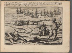
Or there’s an attractive map of St. Helena, rushed into print to capitalize on public interest when it was announced that Napoleon was to be exiled there. Curiously it is geographically outdated; the base map dates from the 1670s.
It is the earliest printing (of four), bearing the imprint of Burgis and Barfoot, dated October 1815. It shows the various landmarks and houses made famous during Napoleon’s residence on the island and marks
'PLANTATION HOUSE The Residence of BUONAPARTE', while 'The Briars' is labelled as the property of 'Mr. Balcombe' and 'Long wood Farm' is described as 'The Residence of the Lieu.t Govr.', reflecting the haste in preparation. In fact, The Briars was Napeolon’s first residence, and then Longworth House, while Plantation House was the governor’s residence. As the map was quickly revised, this earliest state is rare.
But it’s not all about Waterloo:
200 years after it was published, we have a beautiful signed and hand-coloured 1815 first edition of William ‘Strata’ Smith’s ‘Delineation of the Strata of England and Wales, with Part of Scotland’ - the first large-scale, detailed scientific geological map of any country, and the subject of Simon Winchester's bestselling book 'The Map that Changed the World'. This example will be offered for sale at the London Map Fair for £150,000 and is complete with the original ‘Memoir’.
And on a completely different note we have the largest printed map of London. When Richard Horwood’s survey of London was first published in the 1790s, it was the largest map yet printed in the British Isles. The first London map to show house numbers, it is the most important map of the Georgian capital. Despite royal patronage from George III Horwood very nearly ruined himself completing the 32 map-sheets. After he died in penury in 1803, William Faden created this even larger version of the map, published in 1819, revised and extended to include the new docks in the east end. This version of the map was printed in 40 sheets and measures over 2 metres by 5 metres. £18,500
And if you’re looking for something more manageable size-wise we have a tiny pocket globe, only 7 centimetres across. Hand coloured, varnished and housed in a shagreen case, it was made in approximately 1730 by John Fowler, a man better known for his instrument making, and is rare and previously unrecorded. £60,000
EVENTS
This year’s Guest Speakers will be map-seller (and London Map Fair organiser) Tim Bryars and Tom Harper, the British Library’s curator of antiquarian mapping.
Tim and his co-author Tom will be discussing their recently published British Library bestseller A History of the 20th Century in 100 Maps, revealing how maps permeated almost every aspect of daily life in the last century:
‘From the Beatles to the Bomb, from top-secret documents to mass propaganda, maps tell many stories, allowing us to explore changing social attitudes towards the unfamiliar and unconventional, from Jewish London at the turn of the century to women in the workplace, and from the Edwardian opium trade to gay London in the 1980s.’
Some of the maps in the book will also be offered for sale at the fair.
There will also be talks by third-generation mapseller and author Ashley Baynton-Williams throughout the weekend on map collecting for beginners.
The Map Fair is masterminded by three map dealers: Tim Bryars of Tim Bryars Ltd., Massimo De Martini of Altea Antique Maps & Old Charts and Rainer Voigt of Garwood & Voigt. Tim Bryars and Massimo de Martini are available for interview.