17th-Century Japanese Map, Audubon Birds at Swann Galleries’ June 3 Auction


New York—On Tuesday, June 3 Swann Galleries will conduct an auction of Maps & Atlases, Natural History & Color Plate Books—the first sale catalogued by new Maps specialist Alex Clausen—which features exceedingly rare cartographic material and decorative plates.
Among maps of Japan is a masterpiece of urban cartography: an impressive early 17th-century manuscript map of Kyoto as the imperial capital, mounted on a six-panel screen. Screen maps from the early Edo period are very rare, and this maps contains a plethora of detail about Kyoto and its surroundings, showing the city as it looked centuries before 1600 and features the large Heian Palace Complex at its northern end—which was destroyed by fire in 1227 AD. The number and width of each street is noted and a key differentiates buildings used by the imperial household, magistrates, Shinto and Buddhist clergy, military retainers and commoners. Measuring approximately five and a half by 12 and a half feet fully extended, the map has a pre-sale estimate of $60,000 to $90,000.

Additional extraordinary Japan items include two printed maps, one a multi-sheet woodblock folding map of Japan by Ishikawa Ryusen (edited by Sagamiya Tahei), Kyoto, 1697, which contains a host of geographical information that exceeds any previously published maps, with the names of feudal lords of each castle and the incomes in rice of each fief, detailed information related to transportation, with shipping routes drawn on the sea, and a table that lists the names of various cities and regions between China and Southeast Asia. It also lists distances in nautical miles from Nagasaki to as far afield as Holland. The map served as the basis for numerous European mappings in the following century ($20,000 to $30,000). The other is A new map of Kyoto and its surroundings published by Hayashi Yoshinaga, circa 1716-1736, in which Kyoto is shown in its strict symmetrical order with a central axis from the imperial palace to the Rasho-gate, including many entries on the origins and history of Buddhist temples and Shinto shrines ($12,000 to $18,000).

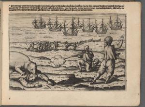
The sale features an unparalleled sketch from life of the Battle of the Nile attributed to Captain James Weir, The French line as they appear'd at an Anchor on the 1st of August 1798. in the Wn. branch of the Nile, a watercolor battle scene from the perspective of Admiral Nelson's squadron as it approached Napoleon's fleet in Abu Qir Bay on the afternoon of 1 August 1798; manuscript notes relate the French and British orders of battle and the fates of the French ships of the line ($20,000 to $30,000).
A run of 16th-century maps of Cyprus includes Giovani Francesco Camocio’s handsome Cyprus, insula nobilissima, published in Venice in 1566 amidst ever-increasing fear of an Ottoman invasion of the island ($15,000 to $25,000); Cyprus, que olim (Macaria), with wide original margins, Rome, circa 1560s ($10,000 to $15,000); Nicolo Nelli’s mapping featuring Cyprus and issued in the year the island was invaded by the Ottomans, it shows the waters around Cyprus teeming with Venetian ships, Venice, 1570 ($8,000 to $12,000); and a very scarce engraved German broadside of the Ottoman fleet sailing to Venetian-controlled Cyprus in 1570, Warhafftige Co[n]terfettung der Turckischen Armata von Balleenn und andern Schiffen Dreihundert wie solche dess 1570, Nuremberg, circa 1570s ($10,000 to $15,000).
Among American cartographic highlights are an incredible set of Post Route Maps documenting the contiguous United States (excluding Florida) in detail, 24 large lithographed folding maps, Washington, 1860s-70s (updated to 1880s) ($20,000 to $30,000); Aaron Arrowsmith’s A Map of the United States of North America, large engraved case map hand-colored by state, in remarkably pristine condition, London, 1802 ($10,000 to $15,000); a map of lower Manhattan that shows Lafayette Street for the first time, with an ink presentation inscription, “To Gen. La Fayette / from T. Longworth, New York / May 13th. 1826” ($3,000 to $5,000).
Atlases of note include the British officer’s “Holster Atlas,” i.e. Robert Sayer and John Bennett’s The American Military Pocket Atlas, with six engraved folding maps, hand-colored in outline, London, 1776 ($7,000 to $10,000); John Melish’s A Military and Topographical Atlas of the United States, Philadelphia, 1813 ($10,000 to $15,000); a quite nice copy of David H. Burr’s An Atlas of the State of New York, with 51 hand-colored maps, Ithaca, 1839 ($10,000 to $15,000) and George M. Wheeler’s Topographical Atlas Projected to Illustrate Explorations and Surveys West of the 100th Meridian, with 85 duotone and color lithographed map sheets, Washington, circa 1874-1881 ($4,000 to $6,000).
Featured among significant books with plates are a first octavo edition of John James Audubon’s The Birds of America, with 500 hand-colored lithographed plates in seven volumes, New York and Philadelphia, 1839-40-44 ($30,000 to $40,000); John Fisk Allen’s Victoria Regia; or the Great Water Lily of America, 1854, one of the most important American natural history books with color plates, here with an extra plate and presentation chromolithograph ($20,000 to $30,000); Michel Etienne Descoutilz’s Flore Pittoresque et Médicale des Antilles, with 600 stipple-engraved plates, printed in colors and finished by hand, mixed edition in eight volumes, Paris, 1833; 1827-29 ($12,000 to $18,000); and a landmark of English chromolithography, Owen Jones and Jules Gourdy’s Plans, Elevations, Sections and Details of the Alhambra, with 102 plates and plans in two volumes, London, 1842-45 ($8,000 to $12,000).
Individual plates of note include Audubon’s Grey Fox. Plate XXI, hand-colored lithograph from Viviparous Quadrupeds, Philadelphia, 1843 ($10,000 to $15,000); his Lark. Plate CXXXVI, hand-colored engraved and aquatint plate from The Birds of America, London, 1832 ($8,000 to $12,000) and one of the most sought-after prints of Colonial New York, John Carwitham’s engraving Fort George with the City of New York from the SW, hand-colored, depicting Manhattan circa 1731-36, London, 1794 ($5,000 to $7,500).
Rounding out the sale are a gilt-brass and silver Augsburg dial compass by Johann Martin, circa 1700 ($4,000 to $6,000); a beautiful English pocket globe by Richard Cushee, measuring two and three quarters of an inch in diameter, London, 1731 ($8,000 to $12,000); and several lots of ephemera, which include photograph albums, currency, royal seals and World’s Fair posters.
The auction will begin at 1:30 p.m. on Tuesday, June 3. The material will be on public exhibition Thursday, May 29 and Friday, May 30, from 10 a.m. to 6 p.m.; Saturday, May 31, from 12 p.m. to 5 p.m.; Monday, June 2, from 10 a.m. to 6 p.m. and Tuesday, June 3, from 10 a.m. to 12 p.m.
An illustrated catalogue with information on bidding by mail or fax is available for $35 from Swann Galleries, 104 East 25th Street, New York, NY 10010, or online at www.swanngalleries.com.
For further information, and to arrange in advance to bid by telephone during the auction, please contact Alex Clausen at (212) 254-4710, extension 17, or via email at aclausen@swanngalleries.com.
Live online bidding is also available via Invaluable.com.
First image: Early 17th-century manuscript map of Kyoto as the imperial capital, mounted on a six-panel screen, estimate: $60,000 to $90,000.
Second image: The French line as they appear'd at an Anchor on the 1st of August 1798. in the Wn. branch of the Nile, watercolor battle scene from the perspective of Admiral Nelson's squadron as it approached Napoleon's fleet in Abu Qir Bay on the afternoon of 1 August 1798, estimate: $20,000 to $30,000.